Trip Report for Marmot Pass
 Where: Olympic National Forest
When: Saturday, September 20, 2014
Stats: 11.8 miles round trip – 4,070 foot elevation gain
As I write this trip report I am reflecting not only on this hike, but on the entire season of hiking I have done (just a few weeks longer than six months). Back in January one of my dogs decided to chew up the pair of hiking boots I had had for just a little over three years. My immediate reaction was to think that I needed to buy a new pair, but then I stopped myself and asked why? I had gone on a few hikes in 2011, a few more in 2012, and none at all in 2013. In fact, as I looked back over the last five or six years, I had hiked irregularly, if at at all. “But,” I said to myself, “I love hiking!” “Well then why don’t you do it more, if you love it so much?” It was then that I made the commitment that if I were to spend the money on a new pair of boots I would have to actually make use of them. I bought my boots in February and did my first hike of the season about three weeks later (Mount Zion).
At that point I was planning on getting out and hiking once a month or so, and my next hike was a little over a month later (Lake Angeles). About this same time I started to realize that what I really wanted to do was to plan things more fully, so I made this spreadsheet and really started thinking about where I wanted to go and how often I wanted to do so. I began talking to many of you at work and seeing who might be interested in going too, because I knew that I would be more likely to keep my commitment to myself if I was also keeping a commitment to other people. A month later I went on my third hike (Upper Dungeness River) and then three weeks later was on my fourth hike (Rattlesnake Ledge). From this point on until the end of August I maintained this three week tempo, and then from the end of August until now sped it up to a hike every two weeks.
Back in May or June I first read the description of Marmot Pass and thought how wonderful it would be to be able to do this hike. At that time, though, 10.6 miles and 3,500 feet of elevation gain seemed so far beyond my reach as to be impossible. I thought that maybe—just maybe—if I worked really hard I might be able to get myself to a position, physically and mentally, where it would be possible. I planned hikes that would challenge me. I set a pace that would keep me doing it. I purchased gear that I thought I would need, and replaced gear that proved itself to be insufficient to the task. September 20th, 2014, I set out to see if I had done enough, and if I really was capable of achieving this dream.
6:45 am is such an early time to be hitting the road for a hike, especially considering that we all worked launch the day before, but somehow or another we were all there and ready to go. The drive down to the ferry was as quick as always and we managed to make it on to the 7:10 sailing instead of having to wait for the later one. This was to prove serendipitous considering how long the rest of the day was to be.
Down at the waterfront and as we crossed the Sound aboard the ferry the skies were dark grey, the wind cold, and the water choppy. It was not until we had driven across Kitsap and on to Olympic Peninsula that we saw signs of clearing overcast and hints of the sun. By the time we were driving through Quilcene and getting close to the trailhead the weather had cleared marvelously and the day was shaping up to great beauty.
We started up the trail from the trailhead (elev. 2,520’) at about 9:10 and were immediately immersed in boreal forest. The rain of a few days past was easily evident in the wetness all about us, and in the rushing clamor of the Upper Quilcene River. That waterway foamed tumultuously over mossy rocks and fallen trees, crashing from level to level as it raced down the pass. The trail was constantly climbing, sometimes rocky, often rooted, and always winding higher and higher. We made good time, taking breaks along the way, and arrived at the first camping spot along the trail, Shelter Rock Camp (2.7 miles from the trailhead, elev. 3,835’). We paused here for ten or fifteen minutes to take our packs off and move around a little. I took this opportunity to adjust the strap placement on my pack to ease the weight off my shoulders. This camp is a beautiful spot, nestled in a pine needle carpeted clearing, surrounded by towering trees, and fronting along a babbling creek. For a large group seeking a not difficult to reach spot with plenty of beauty this would make an excellent camping spot.
From Shelter Rock Camp we continued ascending, winding our way through the forest, ever climbing. From this point on we started to diverge from the river as the trail crawled up the north slope of the valley. Gradually the terrain and surroundings grew drier, whether from having received less rain or from the land simply sucking it in. As we hiked along we were treated to views to the south of Warrior Peak (3.5 miles from the trailhead, elev. 4,505’) and some of the other high areas of the south valley wall. All along this way we found ourselves crossing small streams that were on their way down to the river, some of them offering enchanting and lovely waterfalls both above and below us. For anyone not from this area it is hard describe how clean and clear these mountain waters are, filtering over rocks and moss as they do. It was also along this stretch of the trail that our fatigue began to make itself more clearly felt.
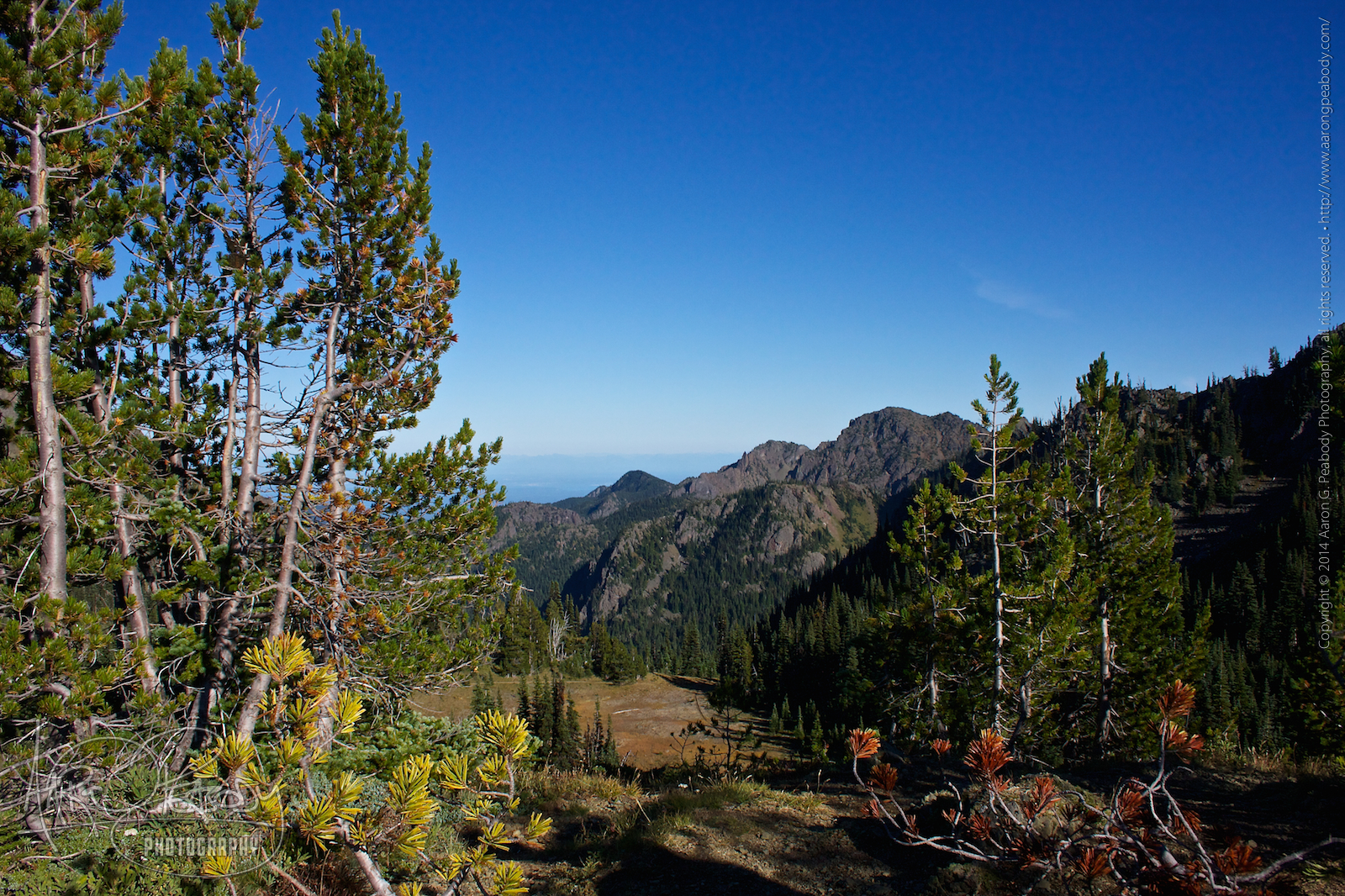
A little ways further along and just shy of 5,000 feet elevation the trail became increasingly rockier. At about 3.8 miles from the trailhead and at an elevation of of around 5,300 feet we found ourselves suddenly out in the open with views of looming stone peaks to the south and north of our position. Instead of hiking along through cedar we were now in the midst of pine and spruce. Visibility was no longer limited to a few hundred feet by thick stands of trees, but was opening up to allow us to see for a mile or more, and sometimes much much farther. Up the valley wall from us were sparse meadows and stands of trees, steeply sloped and easily believed to be the playground of goats, marmots, and mountain lions. Across the valley were more rocky spires. Looking back we could catch glimpses of distant Puget Sound. Looking ahead we could see alpine meadows and the high ridges surrounding the pass. I conjectured that the meadow we could see high above and to the west might be the pass of our goal. Likely what we were seeing was another meadowed ridge-side to the south, and one that we shall return and hike in the future. One of the plants growing profusely along this stretch of trail may have been some species of sage. It was redolent with a scent that combined both sage and lemon, creating a fresh presence in the air that lifted and stimulated our spirits.
Along here is also where we had our first, major wildlife encounter (I don’t count squirrels and chipmunks). Rounding a rock Mike saw something that we soon realized was a small weasel! This was a first for me, never having encountered any sort of mustelid in the wild before. It had a body six to eight inches long, was reddish brown on its back, flanks, and head, and had a cream colored chest, stomach, and feet. Researching it now I believe that it may have been a stoat, or short-tailed weasel as they are sometimes known. It was an adorable little fellow or gal, racing from one side of its rocky home to the other, peering at us with glittering black and curious eyes. Eventually it dashed across the trail and was lost to our sight in the rocks below.
We continued to trek across the side of the mountain here, now on treacherous footing. The ground was covered in rocks of all sizes, ranging from pea gravel to chunks like softballs. We had to pay careful attention to our footing and balance, all the while basking in hot sunlight and peerless vistas. On this rocky way and passing in and out of stands of trees we eventually arrived at Camp Mystery (4.8 miles from the trailhead, elev. 5,380’), the final large camping area below the pass and the last place where you can get water. While a scenic and beautiful area, there is an odor lingering here from too many people spending too many nights and doing too little to properly dispose of their waste. The Forest Service either needs to construct a proper latrine on the site or limit the number of people using it. Despite wanting a rest we pushed on past here quickly.
From Camp Mystery we began to climb once more, passing through meadowed hillsides and switchbacking our way up rocky faces. We came to a spot with gorgeous views, huge boulders, and no smooth ground, and thought that it might be a great place to sling hammocks away from all the campers. Eventually we came out into the side of an open area that lead across a meadow and then up a steep ridge to the pass. It was so beautiful here, painted with colors of red, yellow, brown, and green beneath a blue sky. We talked about what a wonderful place this would be to make camp someday, providing as it does fairly easy access to the pass above and plenty of space to spread out and catch the morning sunrise. We paused here for a little while, me taking lots of pictures, before we made our final push to the pass.
Both on this hike and on the previous one Justin had strapped his big knife to his pack rather than wearing it. His reasoning was that, until he has a better way to secure it to his leg, he doesn’t like the feeling of it constantly banging against his thigh. This thought is foreign to my understanding, as I told him and Mike. I am both used to and like the feeling of something banging against my thigh (get your mind out of the gutter). It’s because I’m so used to wearing Utilikilts and their large pockets. Actually, as I explained it to me buddies, it goes back much further than that. In highschool and college I would often have a wrench and a hammer on my belt because of my theatrical/production work. I grew to associate that weight and feeling with doing work that I love. Though I no longer wear tools with that regularity, my kilts bring a little of the feeling back. So wearing a big knife on my hip, letting it bang away, really is a return to the old pleasure of knowing that I’ve got the right tool close at hand.
A few hundred feet of trail brought us finally to Marmot Pass, elevation 5,950 feet! According to the topographic map I have of the area, getting to this point had us traversing 5.6 miles, which is more than the 5.3 miles that the guidebook claims we should have. Remind me to check my GPS and see what it says we did…
At the pass we dropped our packs, stretched our backs, and revelled in the view. Stunning! Famished we decided to feed ourselves before we did any further exploring. Justin had brought an MRE for himself, while Mike and I had freeze-dried backpacking meals. While Justin assembled his I got my stove lit to boil water. In addition to the Esbit fuel cubes that the stove runs on I tried an experiment using small sticks to see if I could stretch the fuel and boil the water that way. While they certainly burned I think they were not hot enough to cook the water to a boil at this elevation, so I ended up running through all four of the fuel tabs I brought with me. For the future I think I will use this stove only in a pinch, preferring to rely for real meal preparation on something that can generate a hotter flame. More research is needed… In the end, though, Mike had his beef stew and I had my beef stroganoff. After all that time and all that effort I cannot describe to you how wonderful and how delicious that meal was. Suffice it to say I cannot imagine a better way to cap off our climb. Food finished and clean-up done we packed our things up and decided it was time to climb the south ridge and see what was to be seen.
I don’t have a precise measurement for this additional distance, but I’m going to guess that we added on another 1,000 to 1,500 feet. I do know that we ended up ascending to an elevation of 6,295 feet. Wow! What incredible views we found from here there, though. We also found, despite everything we had said at several spots lower down, the place we are going to come back to and camp. An open plateau, dotted with rocks and trees, provides 360° views of the mountains and valleys all around. Numerous spots exist for rest and relaxation, as well as other trails to be explored. From almost any spot you will be able to watch both sunset and sunrise from your tent. The feeling of being at such a high spot, surrounded by the glory of the natural world, drinking in splendor and majesty, is beyond my ability to describe with words or capture with camera. All I can ask is that you take my meager efforts and imagine them ten times better than I can begin to explain. Go there. Be there. You will come to understand that that is the real world, and that this one of internet and iPhones is the illusory one.
As the day progressed and the hour grew later the quality of the light gradually became lower angled and more golden. Rich sunlight splashed amazing colors across the landscape and seemed to light up everything about us from the inside. You could almost feel the rays of light streaming down from the sky, piercing you from head to toe, and connecting you with the world beneath your feet. It was liquid and magic and full of mystery and truth.
We made our way back down to where we had left our packs, took a few more pictures, and then began the long hike toward home. While descending and before collecting our gear we saw our second bit of wildlife. We had been hearing the whistling cry of a marmot for a little while, but Justin finally spotted it in the meadow far below. Having left the binoculars with the packs we could not see it well, but we could definitely tell what manner of critter we were watching bounding about. We all agreed that seeing a marmot at Marmot Pass was pretty much perfect. It was also around this time that Mike uttered Justin’s favorite line of the day. I’m probably paraphrasing here, but Mike said something along the lines of, “today we were down there [looking back down the valley toward Puget Sound] and now we’re up here—that’s fucking amazing!”
Everything we had seen coming up we now saw in reverse, experiencing a different viewpoint and perspective. During the early stages of this bit we talked quite a lot about gearing up for a camping return to this place. Mike is very much on board with that, as well as gearing up so he can do more hiking generally. Welcome to the obsession, Mike! Not long after entering the trees (about where we first saw the views of Warrior Peak hours before) we had to break out our artificial lights. Justin and I each had headlamps that we wore about our necks, while Mike was using a flashlight. I suspect a headlamp is now on his list of things to buy. The greatest challenge at this point, though, was not visibility. Rather it was the effect that the pounding downhill was having on our already stressed bodies. We all had our ailments (mine was my knees), and had to make stops just to rest our abused bodies. We pushed through, though, somehow, and finally made it back to the trailhead around 9:30. Over twelve hours to do a 10.6 mile mike may seem like a lot, but as I check the GPS now it seems that our actual distance covered was just a little over 12 miles! I don’t know if I believe it completely or not, but just looking at the map I know we did at least 11.5, so I’m going to call our time and speed just fine. In fact, I’m going to go ahead and declare our distance covered at 11.8 miles, just to make things nice and tidy.
Back at the car and back out of the woods we drove, making it to Kingston a little before 11:00 We caught the 11:30 ferry, though it seemed that it took much longer, and made our watery way home. I don’t want to presume to speak for my two compatriots, but I was feeling decidedly exhausted and punchy. I passed out at the ferry dock and again on the ferry itself.
By the time we landed we were all really, really hungry, and despite the late hour decided we definitely needed food. So we took ourselves off to the only place we could be sure was open: Denny’s. Oh thou bastion of culinary mediocrity! Gift to us your “slams” of poorly cooked food! Bless us with surly waiters and shifty patrons! Wait a minute… But I digress. We all quaffed hot chocolate and consumed Lumberjack Slams with a third egg added. After all of this I’m honestly not sure how I managed to get us all back to my place, and I can only assume that the other two made it safely to their respective homes. What a day, what a day, what a glorious glorious day!
Epilogue
I can now look backward from this, the Autumnal Equinox, at what the last six months have brought. I have completed ten hikes, ranging from easy to difficult, with most of them in the moderate to difficult range. I have accomplished hikes that a year ago I would have said and was incapable of. I have opened doorways into what I will do in the future, rediscovering myself and making plans for so much more. Unexpectedly I have made some extremely valuable new friendships, and this is, perhaps, the most wondrous part of these six months of all.
Thank you.
Leave a Reply